A warm southerly airflow over the UK will bring milder temperatures than of late but also showery and occasionally windy weather in the run-up to the Easter weekend.
The warmer air being drawn up from France will be a contrast to the Arctic air mass conditions we have seen over much of the country in the last week or so, but it will also bring a number of weather fronts and unsettled spells, particularly in the west.
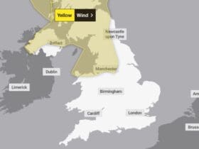
The early part of the week will see some fairly windy conditions in the west, with gusts in places up to perhaps 60mph in the lee of high ground. Showers will be heaviest in the west with the chance of some thundery bursts, while rain will be more persistent in the north, where temperatures will also remain somewhat lower. Where the southeast in particular sees longer spells of sun temperatures may climb to 20C in places.
As the week goes on, something of a northwest/southeast split will develop, but there is some uncertainty over where the divide will settle at present. Showers will be more likely in the north and west, where temperatures will be around average for the time of year. More settled conditions will prevail in the south east, where temperatures could feel really quite warm for spring, pushing into the low 20s C – although even here there may be the odd shower and persistent low cloud in coastal areas will keep them cooler.
Dan Rudman, Deputy Chief Meteorologist, said: “It’s bit of a mixed picture as far as weather is concerned over the long Easter weekend, although feeling warm in places, at least early in the weekend. A low pressure system to the north west of the UK will bring unsettled weather to the north with some strong winds likely and rain in the north west, which could impact driving conditions for some.
“However, further south it will be drier, especially in the southeast, although there will be varying amounts of cloud. Temperature are likely to be above average for the time of year, although low cloud might keep temperatures lower in coastal areas.”


Leave a Reply
View Comments