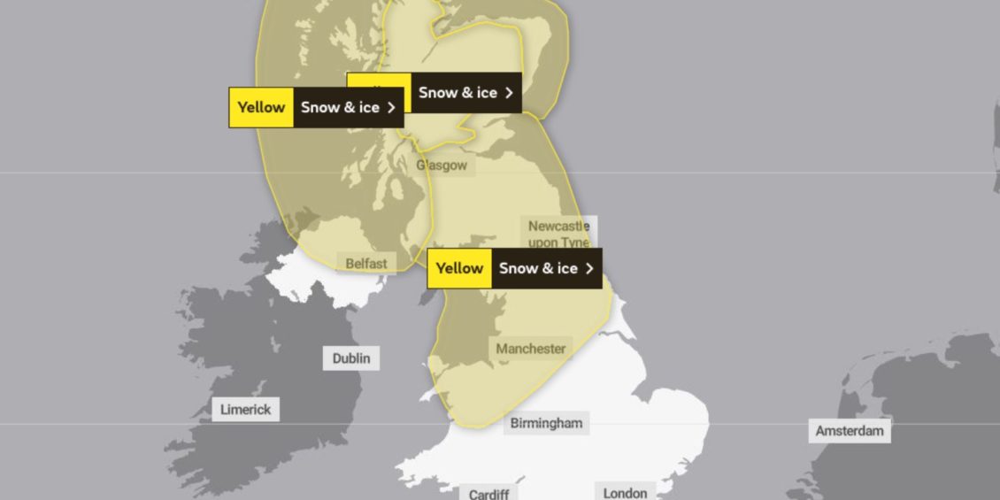
The Met Office has issued a Yellow warning for Wales between Between 17:00 (UTC) on Mon 13 Mar 2023 and 10:00 (UTC) on Tue 14 Mar 2023.
An area of rain will turn to sleet and snow from the north, initially over Scotland, and then over northern England during Monday evening.
Accumulating snow will mostly be above 200-300 m, but possibly to lower levels in Scotland for a time, with 2-5 cm in places. Sleet and snow clearing southeastwards overnight into Tuesday, with temperatures then falling and ice forming, particularly on untreated surfaces.
What to expect
- Some roads and railways likely to be affected with longer journey times by road, bus and train services
- Some injuries from slips and falls on icy surfaces
- Probably some icy patches on some untreated roads, pavements and cycle paths
Regions and local authorities affected
Central, Tayside & Fife
- Angus
- Clackmannanshire
- Dundee
- Falkirk
- Fife
- Perth and Kinross
- Stirling
East Midlands
- Derbyshire
North East England
- Darlington
- Durham
- Gateshead
- Hartlepool
- Middlesbrough
- Newcastle upon Tyne
- North Tyneside
- Northumberland
- Redcar and Cleveland
- South Tyneside
- Stockton-on-Tees
- Sunderland
North West England
- Blackburn with Darwen
- Blackpool
- Cheshire East
- Cheshire West and Chester
- Cumbria
- Greater Manchester
- Halton
- Lancashire
- Merseyside
- Warrington
SW Scotland, Lothian Borders
- Dumfries and Galloway
- East Lothian
- Edinburgh
- Midlothian Council
- Scottish Borders
- West Lothian
Strathclyde
- Argyll and Bute
- East Ayrshire
- East Dunbartonshire
- East Renfrewshire
- Glasgow
- Inverclyde
- North Ayrshire
- North Lanarkshire
- Renfrewshire
- South Ayrshire
- South Lanarkshire
- West Dunbartonshire
Wales
- Ceredigion
- Conwy
- Denbighshire
- Flintshire
- Gwynedd
- Isle of Anglesey
- Powys
- Wrexham
West Midlands
- Shropshire
- Staffordshire
- Stoke-on-Trent
- Telford and Wrekin
Yorkshire & Humber
- East Riding of Yorkshire
- North Yorkshire
- South Yorkshire
- West Yorkshire
- York


Leave a Reply
View Comments